Showing posts with label Hurricane. Show all posts

Sandy Strengthens Overnight

image


# 6674


As predicted by the National Hurricane Center in  Miami, Sandy’s barometric pressure has dropped to an astonishing 946 millibars and its winds have increased to 85MPH, as it moves north at 15 mph.


Although a hurricane at present, Sandy is expected to transition into a post-tropical storm later today as it merges with a trough from the west and cold Arctic air.  


This transition will not diminish the storm’s impact, which is expected to be experienced over a wide area.


This from the 5am Advisory on Hurricane Sandy.


BULLETIN
HURRICANE SANDY ADVISORY NUMBER  28
NWS NATIONAL HURRICANE CENTER MIAMI FL       AL182012 500 AM EDT MON OCT 29 2012

...SANDY STRENGTHENS...EXPECTED TO BRING LIFE-THREATENING STORM SURGE...COASTAL HURRICANE WINDS AND HEAVY APPALACHIAN SNOWS...

SUMMARY OF 500 AM EDT...0900 UTC...INFORMATION
----------------------------------------------
LOCATION...35.9N 70.5W
ABOUT 285 MI...460 KM E OF CAPE HATTERAS NORTH CAROLINA
ABOUT 385 MI...615 KM SSE OF NEW YORK CITY
MAXIMUM SUSTAINED WINDS...85 MPH...140 KM/H
PRESENT MOVEMENT...N OR 360 DEGREES AT 15 MPH...24 KM/H
MINIMUM CENTRAL PRESSURE...946 MB...27.94 INCHES


image 


Local radio & TV stations are streaming coverage over the Internet, including:


Watch Live: Hurricane Sandy Coverage – NBC NYC


Live storm coverage from Eyewitness News – ABC NYC

WINS 1010  News Radio 

»» Read More

The Very Model Of A Natural Disaster

image

Credit NHC 11am Sunday Track Map


# 6673


While it is impossible to know just how bad Hurricane-Hybrid Sandy will be as it approaches and crosses the eastern seaboard over the next 48 hours – or who, exactly, will be most affected – models continue to paint a sobering picture.


Tidal surge models from the National Hurricane Center suggest that large areas of the coastline could see storm tides 5-10 feet above normal. 


The following map is for a 5 ft surge:

image


Some models are suggesting that portions of New York Harbor could see tides exceeding 10 feet above normal, and the 11am advisory warns:


STORM SURGE...THE COMBINATION OF AN EXTREMELY DANGEROUS STORM SURGE AND THE TIDE WILL CAUSE NORMALLY DRY AREAS NEAR THE COAST TO BE FLOODED BY RISING WATERS. THE WATER COULD REACH THE FOLLOWING DEPTHS ABOVE GROUND IF THE PEAK SURGE OCCURS AT THE TIME OF HIGH TIDE...

NC NORTH OF SURF CITY INCLUDING PAMLICO/ALBEMARLE SOUNDS...4 TO 6 FT


SE VA AND DELMARVA INCLUDING LOWER CHESAPEAKE BAY...2 TO 4 FT


UPPER AND MIDDLE CHESAPEAKE BAY...1 TO 3 FT


LONG ISLAND SOUND...RARITAN BAY...AND NEW YORK HARBOR...6 TO 11 FT


ELSEWHERE FROM OCEAN CITY MD TO THE CT/RI BORDER...4 TO 8 FT


CT/RI BORDER TO THE SOUTH SHORE OF CAPE COD INCLUDING BUZZARDS
BAY AND NARRAGANSETT BAY...3 TO 6 FT


Based on the forecast of surge tides, heavy rains, and high winds the City of New York will suspend mass transit routes starting at 7pm tonight.


Gov: MTA will suspend all subway, bus and rail service as Hurricane Sandy advances

Last subway and rail trains will be at 7; last bus at 9pm

By Shane Dixon Kavanaugh / NEW YORK DAILY NEWS


The last time the New York Subway system was shut down due to flooding was for Hurricane Irene in 2011.  The NYC MTA carries more than 8 million passengers on a typical weekday, and shutting down the entire system will take 8 to 10 hours (cite WSJ).


From Johns Hopkins University, we get this `model’ of possible power outages due to Sandy, based on current track forecasts.  


image


MEDIA ADVISORY: Hurricane Sandy – 10 million could lose power

As many as 10 million in the mid-Atlantic will lose power in the coming week, according to a computer model developed by an engineer at The Johns Hopkins University.

Please note: A multicolored map of power outage predictions is available. Email acl@jhu.edu

A map of power outages as predicted by Guikema’s model based on the official National Hurricane Center track and intensity forecast from 18UTC (3 p.m. EDT) on Saturday, Oct. 27.


An engineer at The Johns Hopkins University predicts that 10 million people from northern Virginia through New Jersey and into southeastern Pennsylvania will be without power in the wake of Hurricane Sandy. Seth Guikema (pronounced Guy-keh-ma) and his team have developed a computer model built on outage data from 11 hurricanes to estimate the fraction of customers who will lose power, based on expected gust wind speed, expected duration of strong winds greater than 20 meters per second, and population density. They ran their model using the official National Hurricane Center track and intensity forecast from 18UTC (3 p.m. EDT) on Saturday, and emphasize that the number of power outages could change as the storm progresses and forecasts become more definitive. It is possible that 10 million people is a conservative estimate, Guikema said.


Guikema’s model may help power companies allocate resources by predicting how many people will be without power and where the most outages will take place, and it provides information that emergency managers can use to better prepare for storms. Guikema, an assistant professor in the Department of Geography and Environmental Engineering at the Johns Hopkins Whiting School of Engineering, says the goal is to restore power faster and save customers money. Guikema will be running the model throughout the weekend and into next week as Hurricane Sandy makes landfall.


The Governor of New Jersey warned yesterday that power could be out for some residents for `seven to ten days’.  And for many people, that means no ability to cook, or to heat their homes.


Municipal water supplies, or water quality, could be affected as well.   Hence the need to be prepared to go several days - at least - without city services or utilities.


And while most people automatically worry about storm surge or high winds from hurricanes, between 1970 and 1999, the most lives have been claimed due to inland flooding. 


image


The NHC has released this five-day precipitation forecast, which should provide some idea of the extent of flooding that may occur.


image


While it is possible that Sandy won’t be as destructive as has been billed, storms like Camille, Andrew, and Katrina have shown us the folly of underestimating nature’s fury.


Today is the last day that people in the path of this storm will have to prepare. Those who are ordered to evacuate need to do so immediately.


To help track this storm, you may wish to revisit my blog from yesterday  Resources To Follow The Northeast Storm Online.

»» Read More

Resources To Follow The Northeast Storm Online


image 

Credit NWS Binghamton,NY


# 6671


Hurricane Sandy is being billed as having the potential to become a major New England storm when it merges with a mid-latitude trough coming in from the west early next week. It is even being compared with the `perfect storm’ of 1991, and so local, state and Federal emergency planners are burning the midnight oil this weekend in preparation.


There is always the possibility that Sandy will prove less damaging than feared, but one can’t simply assume that the Mid-Atlantic and New England states will get lucky.


The internet provides a unique platform for watching Sandy’s trek across Northeastern states, with resources that include live coastal radars, NOAA weather radio broadcasts, streaming radio and TV coverage from cities all across the region,  beach front and traffic webcams and even scanners to listen to local emergency radio traffic.


For those in the path of the storm, or those with friends or family in the affected area, this can help provide valuable information as to what is going on during and after the storm.


And for those who are simply curious as to the impact of this hurricane, this is a convenient way to monitor it.


Disclaimer: These links are offered without warranty or endorsement (except for the NHC & NOAA links), and you visit them at your own risk.


It is always prudent to use up-to-date antivirus software, and decline to install any software from vendors you do not trust, when surfing the net.


Official sources are always your best option, so when it comes to getting the latest information on hurricanes, your first stop should be the National Hurricane Center in Miami, Florida.


These are the real experts, and the only ones you should rely on to track and forecast the storm.


To get their latest forecasts – particularly if the power is out in your area – you really need a battery operated Weather radio. Once thought of as mainly a source of local weather information, it has now become an `All-Hazards' alert system as well.


image


You’ll find that  NOAA Weather Radio All Hazards broadcasts are available online via live streaming audio hosted by other entities, like  Weather Underground. This allows you to listen to broadcasts outside of the range of your receiver.


The second official information source you should have bookmarked is your local Office of Emergency Management.  There you will find information about evacuation zones, shelters, and emergency decrees in your area.


If you are on Twitter, you should also follow @FEMA, @CraigatFEMA, @NHC_Atlantic, @NHC_Pacific and @ReadydotGov.


You can access live feeds from the nation’s array of NEXRAD and TDWR radar installations, via this link at Weather Underground.

image


Live beach cams line the coast, and as this screen capture this morning from Kill Devil Hills, NC shows, the weather there is already deteriorating.

image

Raleigh broadcaster WRAL.Com has an interactive map with a number of these cams available.

image

The most extensive list of Northeastern Webcams I’ve found so far is HERE, although one should expect that some  of these will be out of commission as the storm approaches, or slow to load due to heavy internet traffic.


Live streaming radio on the internet has grown remarkably over the past few years, and this site has links to thousands of stations. Choose Radio Stations by State to narrow down your search.


image


Local, county and state emergency services frequencies (fire, police, EMS) can be assessed via RadioReference.com.  Their interactive maps allows you to first pick a state, and then drill down to the county you are looking for, where you’ll be presented with a list of feeds.


image

With more than 3,300 feeds there’s a pretty good chance you can monitor nearly every place in the country.


Hurricane City, a well known hurricane tracking site and forum, broadcasts on USTREAM when hurricanes approach the coast and you can watch it HERE.


You’ll also find live hurricane coverage and chaser cam footage from Mark Sudduth’s HurricaneTrack.com.


USTREAM, mentioned earlier, provides a venue for all types of broadcasting.  Enter  HURRICANE  or SANDY or FRANKENSTORM  in the search box for a list of current streaming video. You’ll find everything from storm chaser video to live feeds from hotels on the Altantic beaches.


Since anyone can broadcast on USTREAM, accept anything you see or hear cautiously. Still, USTREAM can be a terrific resource.


I’ll try to have more resources later, and will update this blog post if I find anything tonight. But this should give you a pretty good start on following the storm.

»» Read More

Preparing For After The Storm Passes


image

Minimum Preps : Emergency Weather Radio, First Aid Kit, Battery Lantern, Water storage


# 6664


Although still battering the Bahamas, Hurricane Sandy is looking increasingly like it will pose a threat to the United States Mid-Atlantic and New England regions over the next 3 or 4 days. 


Exactly how strong it will be, and what areas it will impact are unknown, although the following graphic from the National Hurricane Center’s 5am forecast gives us some pretty good ideas. 


image


As hurricanes move north they often expand in size, rather than strength. Even when they lose their tropical characteristics (become a post-tropical storm) their winds can remain very strong, but are less centralized.


In other words, whether Sandy remains a hurricane all the way to landfall is of little consequence.  This storm has the potential to cause a lot damage and disruption over a wide area.


Inland flooding, coastal flooding, and power outages are  likely threats, although substantial wind damage - and even tornadoes - are possible as well.


Those in the path of this storm who have extra food, water, provisions for emergency lighting, a first aid kit, an emergency weather radio, and a family emergency plan are likely to fare far better than those who fail to prepare.


The next 48 - 72 hours provides an excellent opportunity for those who have not already done so to put together their family emergency plan and to lay in any last minute provisions.


Often the real danger comes after the storm has passed - during the cleanup and recovery period - when utilities and other services may be out for days.


So with that in mind, a review this morning of food safety after the power goes out, storm cleanup and chainsaw safety, and the dangers of carbon monoxide poisoning from generators.


Food safety after a power outage is often a concern after a storm, something I covered back in 2010 in USDA: Food Safety When The Power Goes Out.  


A few excerpts include:


The USDA maintains a Food Safety and Inspection website with a great deal of consumer information about how to protect your food supplies during an emergency, and how to tell when to discard food that may no longer be safe to consume.


First, an audio podcast (5 minutes).

Surviving a Power Outage: Don't Be in the Dark When it Comes to Food Safety (Jun 2, 2010; 4:45) | Script

FSIS Food Safety staff discusses tips on how to be food safe during a power outage.


The USDA also maintains a large repository of food safety information available to be read online, or downloaded as a pdf.


A Consumer's Guide to Food Safety: Severe Storms and Hurricanes

Note: This text-only version of the Guide has been optimized for accessibility. The illustrated PDF version (2.1MB) is recommended for printing.


Regarding post-storm cleanup, the the Peachtree City, Georgia NOAA weather page has some useful information, including dealing with repair contractors.


This is just an excerpt, follow the link for a lot more:


Safety After the Storm

Here are just a few safety tips...

  • Be aware of hazards from exposed nails and broken glass.
  • Do not touch downed power lines or objects in contact with downed lines. Report electrical hazards to the police and the utility company.
  • If it is dark when you are inspecting your home, use a flashlight rather than a candle or torch to avoid the risk of fire or explosion in a damaged home.
  • If you see frayed wiring or sparks, or if there is an odor of something burning, you should immediately shut off the electrical system at the main circuit breaker if you have not done so already.
  • If you smell gas or suspect a leak, turn off the main gas valve, open all windows, and leave the house immediately. Notify the gas company, the police or fire departments, or State Fire Marshal's office, and do not turn on the lights, light matches, smoke, or do anything that could cause a spark. Do not return to your house until you are told it is safe to do so.
  • For more information, visit the Centers for Disease and Prevention. They have a wealth of information about what to do in the aftermath of all sorts of events - like tornadoes, floods, hurricanes, and many more.


Chainsaw accidents are common after storms as people work under adverse conditions to clear debris.  The CDC maintains a chainsaw safety webpage.  Excerpts follow:


Preventing Chain Saw Injuries During Tree Removal After a Disaster
image
Be aware of the risk of chain saw injury during tree removal

Each year, approximately 36,000 people are treated in hospital emergency departments for injuries from using chain saws. The potential risk of injury increases after hurricanes and other natural disasters, when chain saws are widely used to remove fallen or partially fallen trees and tree branches.


Gasoline generators, along with improvised cooking and heating facilities, can put people at risk of Carbon Monoxide poisoning. Each year, hundreds of Americans die from exposure to this odorless and colorless gas.


With chilly temperatures forecast after the storm - and the possibility of widespread  power outages - the potential for this sort of preventable tragedy in the post-storm period can’t be ignored.


In Carbon Monoxide: A Stealthy Killer I wrote in depth on the issue, but a few tips from the CDC include:


Prevention Guidelines

You Can Prevent Carbon Monoxide Exposure
  • Do have your heating system, water heater and any other gas, oil, or coal burning appliances serviced by a qualified technician every year.
  • Do install a battery-operated CO detector in your home and check or replace the battery when you change the time on your clocks each spring and fall. If the detector sounds leave your home immediately and call 911.
  • Do seek prompt medical attention if you suspect CO poisoning and are feeling dizzy, light-headed, or nauseous.
  • Don't use a generator, charcoal grill, camp stove, or other gasoline or charcoal-burning device inside your home, basement, or garage or near a window.
  • Don't run a car or truck inside a garage attached to your house, even if you leave the door open.
  • Don't burn anything in a stove or fireplace that isn't vented.
  • Don't heat your house with a gas oven.


And as a last stop on our preparedness tour, a visit to the CDC’s Emergency Preparedness and Response  website, which provides advice on a variety of post-storm topics including electrical and fire hazards, mosquitoes, mold, unstable buildings and structures, and the dangers posed by wild and stray animals.


Prevent and Treat Other Illnesses and Injuries After a Hurricane or Flood

 image


    While many believe the worst will be over once the storm has passed, in truth, often the biggest challenges are found during the days and weeks that follow.


    For more preparedness information I would invite you to visit:


    FEMA http://www.fema.gov/index.shtm

    READY.GOV http://www.ready.gov/

    AMERICAN RED CROSS http://www.redcross.org/

    »» Read More

    Sandy: Northeast Increasingly Under The Gun

    image


    # 6663


    Looking like a gigantic question mark (?), the majority of the forecast models for (currently CAT 2 Hurricane) Sandy now have the storm making a sharp left turn towards the Northeast Coast early next week. 


    Sandy’s eventual path, and strength at that time is impossible to gauge right now, but the NWS is asking East Coast residents to pay attention.


    This from the NOAA  National Severe Storms Laboratory Facebook Page.


    Pay attention east coast!


    The majority of computer models have trended toward bringing the system north into the Atlantic just off of the Eastern Seaboard and taking a sharp left turn, ultimately moving into the Northeast. Where exactly the system will go remains up in the air. Models are showing the storm entering New Brunswick to as far south as southern NJ. More info as we get it and we will be following this extremely close over the next 3-4 days. Please share this graphic to keep family and friends informed.


    While Sandy is unlikely to maintain hurricane status that far north this late in the year, residents anywhere from the Mid-Atlantic all the way up to the Maritimes need to pay attention, and be prepared to deal with what could be an extremely strong Nor’Easter or post-tropical storm.


    This Hazardous Weather Outlook from NWS Boston, MA. issued today at 5:47am.


    THIS HAZARDOUS WEATHER OUTLOOK IS FOR NORTHERN CONNECTICUT...CENTRAL MASSACHUSETTS ... EASTERN MASSACHUSETTS ... NORTHEASTERN MASSACHUSETTS  ... SOUTHEASTERN MASSACHUSETTS ...WESTERN MASSACHUSETTS ...SOUTHERN NEW HAMPSHIRE ...  NORTHERN RHODE ISLAND AND SOUTHERN RHODE ISLAND.

    .DAY ONE...TODAY AND TONIGHT.

    HAZARDOUS WEATHER IS NOT EXPECTED AT THIS TIME.

    .DAYS TWO THROUGH SEVEN...FRIDAY THROUGH WEDNESDAY.

    CONFIDENCE CONTINUES TO INCREASE FOR IMPACTS FROM SANDY...WHETHER IN TROPICAL OR POST TROPICAL FORM...EARLY NEXT WEEK. THE REGION
    COULD SEE EITHER A CLOSE PASS OR A DIRECT HIT FROM LATE MONDAY TO TUESDAY AND BEYOND. IMPACTS MAY INCLUDE HIGH SEAS AND STORM SURGE THAT COULD COMBINE WITH HIGH ASTRONOMICAL TIDES TO PRODUCE COASTAL FLOODING...WIND GUSTS POTENTIALLY REACHING HURRICANE FORCE CAUSING DOWNED TREES AND POWER LINES AS WELL AS HEAVY RAINFALL
    RESULTING IN INTERIOR FLOODING.


    Anyone living in the path of this storm, including those living inland, should be making preparations now to deal with it’s arrival.  


    When it comes to getting the latest information on hurricanes, your first stop should always be the National Hurricane Center in Miami, Florida. These are the real experts, and the only ones you should rely on to track and forecast the storm.


    The second official information source you should have bookmarked is your local Office of Emergency Management.  There you will find information about evacuation zones, shelters, and emergency decrees in your area.


    If you are on Twitter, you should also follow @FEMA, @CraigatFEMA, @NHC_Atlantic, @NHC_Pacific and @ReadydotGov.


    Whether Sandy retains tropical characteristics or not, If you haven’t already downloaded the Tropical Cyclone Preparedness Guide, now would be an excellent time to do so. It is a short (12-page), easy to follow guide that will walk you through the basics of understanding (and surviving) hurricanes and tropical storms.

    image

    »» Read More

    The Limits Of Intensity Forecasting

    image  Source NHC


    # 6521


    The 8am EST advisory from the National Hurricane Center finds Isaac close to hurricane strength this morning as he slogs towards the northern Gulf coast at 7 miles per hour. Isaac will be pushing substantial storm surge (6-12 feet) towards the coast, along with high winds, rain, and the potential for tornadoes.  


    Hurricane or not, Isaac remains a serious threat and is deserving of respect. 


    Two days ago forecasters had already accurately predicted a Louisiana/Mississippi landfall - but they also expected Isaac to a strong CAT 2 storm by now. At least one model (HWRF) suggested a low CAT 3 intensity.


    So what happened?


    While forecast path prediction has come a long ways in the past 30 years, comparatively little progress has been made in intensity predictions.  


    The number of atmospheric, oceanic, and land influences on budding tropical systems make it very difficult – with today’s technology – to accurately predict intensity changes 24 to 48 hours out.


    We’ve often seen storms fail to reach their predicted potential, while others have rapidly intensified beyond any reasonable expectations.


    Unexpectedly, Hurricane Charlie jumped from a CAT 2 storm to a CAT 4 storm in a matter of a couple of hours just before slamming into Southwest Florida in 2004.

    image


    This vexing subject was the topic of a presentation last year at the National Hurricane Conference.


    image


    It’s a fascinating 22-page document, but the upshot is, there’s not much hope that intensity forecasting is going to catch up with the recent gains in track forecasting anytime soon.


    image


    All of this uncertainty over storm intensity makes life very difficult for emergency managers.  They must decide – 48 hours in advance of a storm – whether to call for evacuations.


    And the stakes are very high.


    Evacuations are expensive, horribly inconvenient, and have the potential to claim more lives than the storm itself. During the evacuation of the Texas Gulf coast in advance of Hurricane Rita in 2005, more than 90 people died. 


    And storms that failed to live up to their billing only serve to convince people not to evacuate the next time a storm threatens.


    Be glad it isn’t your call.


    In time, intensity forecasting will hopefully improve.  But tropical storms and hurricanes are complex and dynamic systems, and will probably always have the ability to throw us a curve.


    All of which highlights the importance of individual, family, and community preparedness.  We must always be prepared for the unexpected.


    National Preparedness Month is just a few days away, and the folks at FEMA, and READY.GOV would like to encourage you to learn how to make a plan,  build a kit, and be informed.

    image


    And all next month I’ll be featuring preparedness articles in my blog.

    »» Read More

    Isaac Threatens Northern Gulf Coast

     *** UPDATED *** 

    11 am Track from the NHC image-

    As of the 11am update:  THE HURRICANE WATCH IS EXTENDED WESTWARD ALONG THE LOUISIANA COAST TO JUST EAST OF MORGAN CITY...INCLUDING METROPOLITAN NEW ORLEANS
    AND LAKE PONTCHARTRAIN.


    # 6519


    While the forecast is gradually improving for the west central peninsula of Florida, the threat of Isaac making landfall anywhere from the panhandle west to Louisiana has increased overnight.


    With each model run, the forecast track has shifted a little more to the west. As you can see by the spaghetti models below, there remains a fair amount of divergence in forecast tracks.


    image


    Today’s  11am Discussion cautions:


    SINCE THE DYNAMICAL MODEL CONSENSUS HAS SHIFTED WESTWARD...THE OFFICIAL TRACK FORECAST IS MOVED A BIT TO THE WEST OF THE PREVIOUS ONE.  THIS REQUIRES AN EXTENSION OF THE HURRICANE WATCH WESTWARD ALONG THE LOUISIANA COAST.  IT SHOULD BE NOTED THAT THERE IS GREATER THAN USUAL UNCERTAINTY IN THE TRACK FORECAST.


    Isaac remains a tropical storm, but conditions are generally favorable for intensification over the next 48 to 72 hours. The National Hurricane Center estimates that Isaac could be a Category 2 hurricane before it nears the coast.


    image


    And a reminder, you don’t have to be directly in the path of this storm to be affected by it. 


    Tropical Storm force winds extend 200 miles from the center, and landfalling tropical systems have been known to generate tornadoes and cause flooding hundreds of miles away.


    image


    Finally, the end of May was National Hurricane Preparedness week.  You can revisit some of this year’s PSAs and preparedness advice from NOAA by clicking this link, or the graphic below.

    image

    »» Read More

    Hurricane Warnings Raised For South Florida


    image

    # 6518


    The nemesis of tropical storms and hurricanes is the crossing of land, as that interrupts the fuel supply they derive from passing over warm ocean waters.  Mountainous terrain can further disrupt their circulation, and many a storm has thrashed themselves to pieces crossing Cuba or Hispaniola.


    The latest forecast from the NHC has Isaac attempting to thread the needle between the elevated terrain of Haiti to its east, and Cuba to its west, as it moves in a northwesterly direction through the Windward Passage.


    image


    All of which suggests Isaac will spend less time over land than previously thought, and has a better opportunity to intensify to hurricane strength before reaching the Florida Keys.


    Accordingly, overnight Hurricane warnings have been posted for:


    • The Florida Keys, including the Dry Tortugas
    • The West Coast of Florida from Bonita Beach Southward to Florida Bay


    The National Hurricane Center’s  5am Discussion has this to say about Isaac’s future.


    GIVEN THAT THE CYCLONE HAS FARED RATHER WELL AFTER MOVING ACROSS HAITI...AND THAT THE TRACK FORECAST HAS ONLY MINIMAL INTERACTION WTH CUBA...THE INTENSITY FORECAST AFTER 12 HOURS HAS BEEN ADJUSTED UPWARD FOLLOWING THE TREND OF THE LATEST INTENSITY GUIDANCE.


    ISAAC ISEXPECTED TO BECOME A HURRICANE IN ABOUT 36 HOURS...WITH ADDITIONAL INTENSIFICATION EXPECTED AS THE CYCLONE MOVES INTO THE EASTERN GULF OF MEXICO IN A FAVORABLE ENVIRONMENT. THE NEW NHC INTENSITY FORECAST IS CLOSE TO THE INTENSITY CONSENSUS AIDS THROUGH 72 HOURS AND FOLLOWS A BLEND OF THE DECAY SHIPS AND LGEM AFTERWARD.


    image


    Given that Tropical Storm force winds extend more than 200 miles from the center, the exact path of Isaac is of less importance than one might think.


    Tropical storm conditions may be expected along much of Florida’s west coast (and even into the center of the state) over the next couple of days.


    image


    Landfall is now expected in about 3 days along the northern Gulf coast, and the storm could be approaching CAT 2 strength at that time.


    Despite not yet achieving hurricane strength, residents along the path of this storm need to be making their preparations for Isaac’s arrival.


    When it comes to getting the latest information on hurricanes, your first stop should always be the National Hurricane Center in Miami, Florida. These are the real experts, and the only ones you should rely on to track and forecast the storm.


    The second official information source you should have bookmarked is your local Office of Emergency Management.  There you will find information about evacuation zones, shelters, and emergency decrees in your area.


    If you are on Twitter, you should also follow @FEMA, @CraigatFEMA, @NHC_Atlantic, @NHC_Pacific and @ReadydotGov.


    And a reminder, this year emergency management officials are trying once again to dispel the widespread belief that taping windows provides protection during a hurricane (see The Tale Of The Tape).


    Up until the 1970s, it was pretty much standard advice to homeowners to tape plate glass windows to keep them from shattering, but that advice was discredited, and has not been part of hurricane prep advice for 30 years.


    Not only does taping windows provide a false sense of security, it can bind shards of flying glass into larger, and more dangerous, projectiles.


    Still, the myth hangs on.


    A video that I’ve highlighted in the past, from the Pinellas County Office of Emergency Management demonstrates just how useless masking, or duct taping your your windows really is during a storm (be patient, it can take a minute to load).


    Tape Strikes Out

    Tape Strikes Out

    Time: 4 min.

    When a storm blows in, you put masking tape on your windows and you're fine right? We'll show you just how wrong that assumption can be.


    If you haven’t already downloaded the Tropical Cyclone Preparedness Guide, now would be an excellent time to do so. It is a short (12-page), easy to follow guide that will walk you through the basics of understanding (and surviving) hurricanes and tropical storms.

    image

    »» Read More

    Remembering Andrew: 20 Years Ago Today


    # 6514

    [IMAGE LINK]

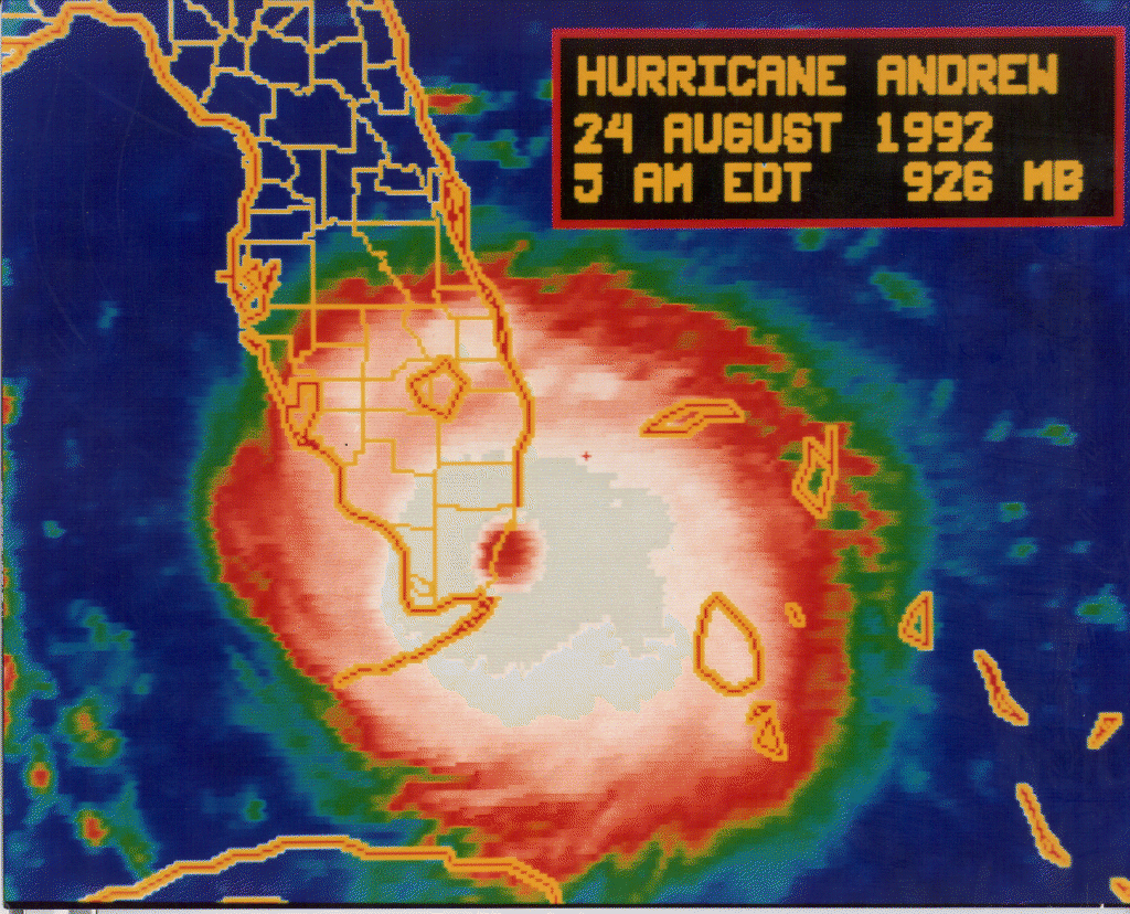
    Infrared image of Andrew over Dade county

    0900 UTC August 24, 1992. (566K GIF)

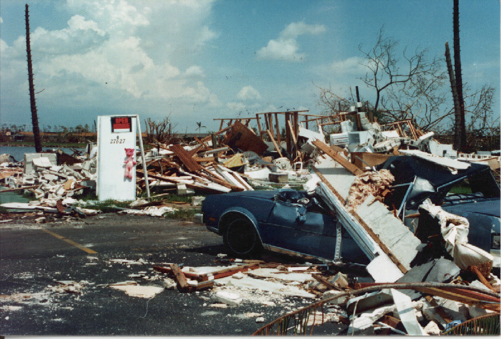
    Today marks the 20th anniversary of Hurricane Andrew, which struck Homestead Florida with CAT 5 force on August 24th, 1992.


    I was living aboard my 36 foot sailboat on the west coast of Florida at the time, making hurried plans of what I would do if this monster storm turned in my direction.


    As it turned out, I was spared Andrew’s wrath, only to be clobbered 7 months later by the 1993 `storm of the century’.

    So today, as we watch an increasingly active Atlantic Basin and  the threat posed by a much weaker Isaac heading for the Gulf of Mexico, a remembrance of that disaster 20 years ago.


    Here is how Ed Rappaport, of the National Hurricane Center (updated 10 December 1993) described the storm.


    Andrew was a small and ferocious Cape Verde hurricane that wrought unprecedented economic devastation along a path through the northwestern Bahamas, the southern Florida peninsula, and south-central Louisiana. Damage in the United States is estimated to be near 25 billion, making Andrew the most expensive natural disaster in U.S. history1.


    The tropical cyclone struck southern Dade County, Florida, especially hard, with violent winds and storm surges characteristic of a category 4 hurricane (see addendum on upgrade to category 5) on the Saffir/Simpson Hurricane Scale, and with a central pressure (922 mb) that is the third lowest this century for a hurricane at landfall in the United States.


    In Dade County alone, the forces of Andrew resulted in 15 deaths and up to one-quarter million people left temporarily homeless. An additional 25 lives were lost in Dade County from the indirect effects of Andrew2. The direct loss of life seems remarkably low considering the destruction caused by this hurricane.


    Since this writing, of course, we've seen even greater destruction and loss of life caused by Hurricane Katrina in 2005.


    Whether it is an earthquake, a flood, a hurricane, or a pandemic . . .those who are prepared in advance will find their survival, and even their comfort, greatly enhanced during an emergency.


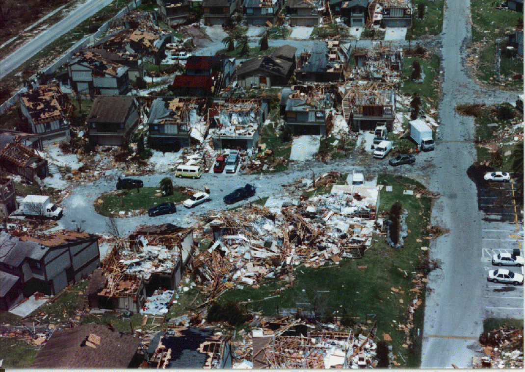
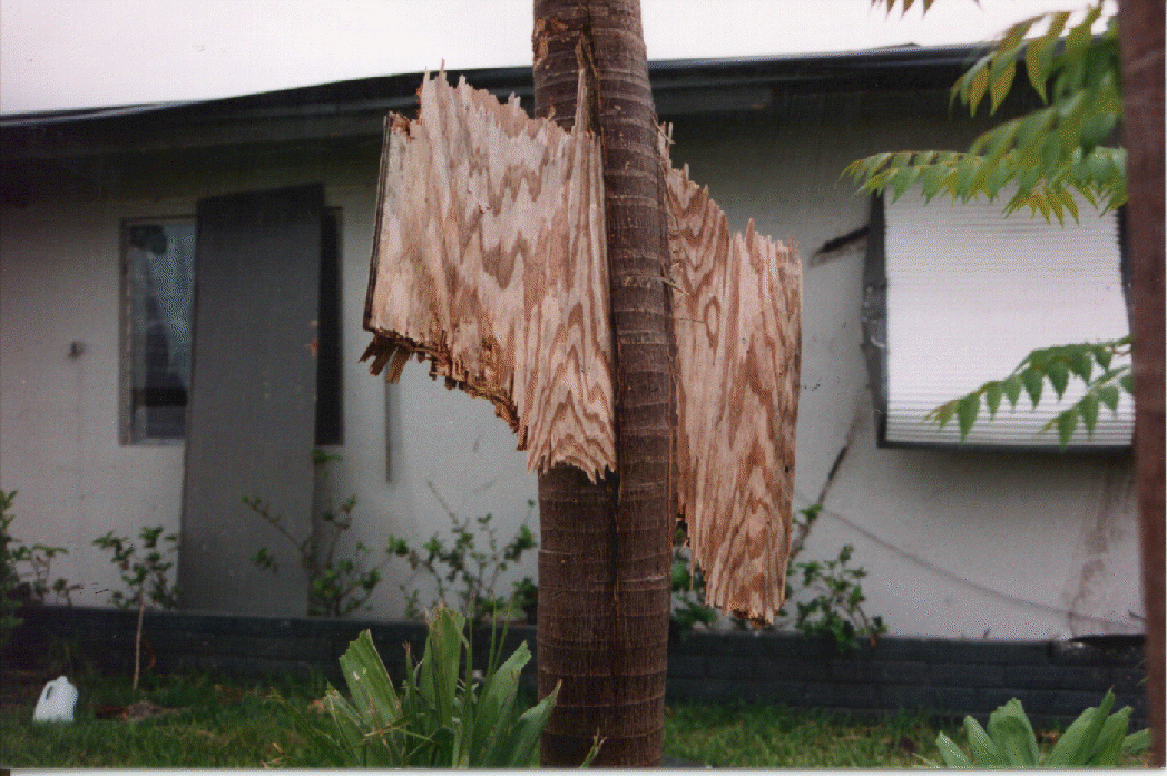
    If you aren't convinced on the importance of being prepared for the  unexpected, just click on the pictures below. 

    They are hard to argue with.


    STORM IMAGES (Credit NOAA)

    (click to enlarge, but warning: Some are very large)


    [IMAGE LINK]

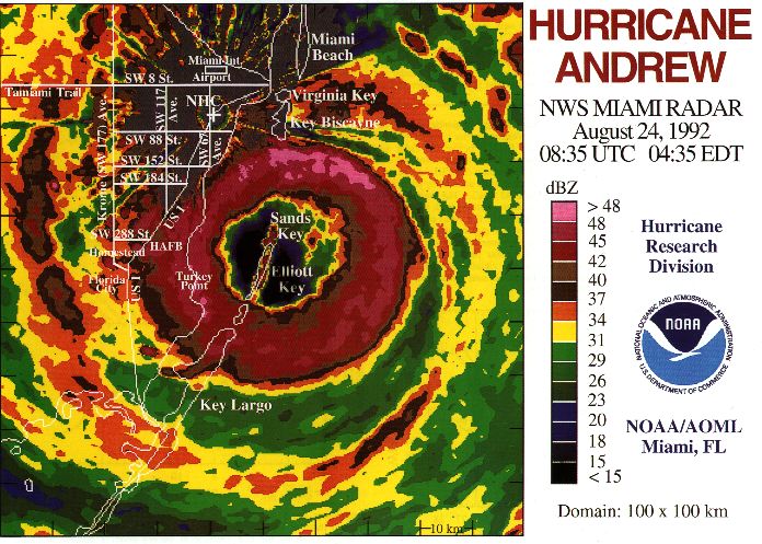
    The last radar image taken from NHC before the WSR-57 radar was blown off the roof, 0835 UTC August 24, 1992. (120K JPEG)


    ANDREW'S DAMAGE


    [IMAGE LINK]
    The roof sign says it all! (555K GIF)


    [IMAGE LINK]
    Lakes by the Bay (751K GIF)


    [IMAGE LINK]
    Naranja Lakes (524K GIF)


    [IMAGE LINK]
    Naranja Lakes (520K GIF)


    [IMAGE LINK]
    Homestead Fl. (530K GIF)


    [IMAGE LINK]
    Homestead Fl. (434K GIF)


    image

    Devastating hurricanes like Andrew may only come around infrequently, but they do happen.  And as Florida’s SERT reminds us;

    It only takes one.

    Meanwhile, the latest forecasts from the NHC on T.S. Isaac are increasingly encouraging for the west coast of Florida, but less so for the upper-middle Gulf coast.  

    image


    As the 5am Discussion this morning states:

    IT IS IMPORTANT NOT TO FOCUS ON THE EXACT TRACK DUE TO UNCERTAINTIES IN THE INITIAL LOCATION AND THE TRACK FORECAST...AND THE FACT THAT ISAAC HAS A LARGE AREA OF TROPICAL STORM FORCE WINDS ASSOCIATED WITH IT.


    Much will depend on how well the storm hangs together as it passes over Haiti and then Cuba, and how quickly it coalesces once over the warm waters of the Gulf of Mexico. 


    Computer models become more reliable once a storm reaches, and maintains, hurricane strength.   


    In any event, all interests along the Gulf Coast, from Texas to Florida, need to keep an eye on this storm over the weekend.

    »» Read More

    Isaac’s Uncertain Future


    image

    # 6513


    The National Hurricane Center has released their 11am forecast update on T.S. Isaac, and while the storm remains poorly organized, the forecast envisions a strengthening system as it crosses Haiti late tomorrow.


    How much mountainous terrain the storm must cross, and exactly when it begins an anticipated more northwesterly turn, will determine just how much of an impact this storm will have on Florida early next week.


    The 11 am discussion warns that: SIGNIFICANT UNCERTAINTY REMAINS ABOUT THE THREAT ISAAC POSES TO FLORIDA.


    The forecast, for now, has Isaac at potentially hurricane strength off the west coast of Florida on Tuesday - but as the width of the `forecast cone’ suggests - it could be anywhere from off the east coast of Florida to the middle of the Gulf of Mexico.


    image


    As I’m sitting in the North East Quadrant of where the storm is forecast to be come Tuesday, I’ve already begun making plans. 


    While I don’t anticipate it will become necessary, I’ve several pre-arranged places I can bug-out to, if evacuations are ordered in my area.


    Knowing where you will go is essential, if you live in an evacuation zone. In addition, I’m always ready to leave at a moment’s notice (see Inside My New Bug Out Bag).  

    bob 001a

    My Bug-out-bag, Canteen, & Toiletry kit


    A bug-out-bag should be a smaller version of a much larger emergency supply that every household should maintain. While a BOB should provide for 72 hours of your family's needs, if you live in hurricane country you should be prepared to stay at home, without outside assistance, for at least 1 to 2 weeks.


    For more on how you can put together an emergency bug-out kit for you and your family, you may wish to visit Ready.gov  for some additional advice.


    image


    A reminder that September is National Preparedness Month, and so I’ll be doing a lot of preparedness blogging next month. 


    If you haven’t already downloaded the Tropical Cyclone Preparedness Guide, now would be an excellent time to do so. It is a short (12-page), easy to follow guide that will walk you through the basics of understanding (and surviving) hurricanes and tropical storms.

    image


    When it comes to getting the latest information on hurricanes, your first stop should always be the National Hurricane Center in Miami, Florida. These are the real experts, and the only ones you should rely on to track and forecast the storm.


    The second official information source you should have bookmarked is your local Office of Emergency Management. 


    If you are on Twitter, you should also follow @FEMA, @CraigatFEMA, @NHC_Atlantic, @NHC_Pacific and @ReadydotGov.


    While it may seem to be a lot of work to get prepared to deal with an emergency, it really isn’t.

    Preparing is easy.


    It’s worrying that’s hard.

    »» Read More